Where Exactly is Swansea, Toronto?

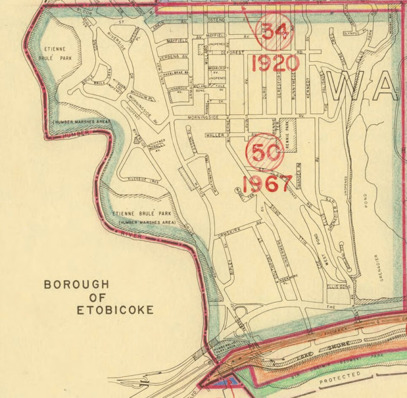
Located in the west end of Toronto, Ontario in Canada, the community of Swansea is bounded by High Park on the east, the Humber River on the west, the railway tracks on the south, and a line 110′ south of Bloor St. W. on the north.
You will notice from area 34 on the Annexation map above, that Swansea actually begins, not at Bloor St, but approximately 110 feet south of Bloor. This 110 feet is often not mentioned in descriptions of Swansea and neglected in some maps, but there are posts on some streets to this day showing the boundary location.
How did this come about?
The Village of Swansea existed as a separate municipality from 1926 until 1967. Bloor Street was extended on the northward end of Swansea in 1914-1916. While upgrading Bloor Street and extending the streetcar to Jane, The City of Toronto had the foresight to annex that 110 feet on the south side of Bloor in 1920, in order to get the tax revenue from the businesses. When Swansea was incorporated in 1926, that 110 feet of real estate was no longer available to be part of Swansea. It is remarkable that Swansea managed to remain solvent in the Depression despite this loss of potential revenue.
Swansea was a part of York Township until 1926 when it was incorporated as a village with 3255 residents. By 1936, it was the second largest village in Ontario and considered a model of a well-run village with its good industrial base in the south and low taxes. Then, on January 1st, 1967, Swansea was amalgamated into the City of Toronto (see area 50 on the above map), but it never diminished as a community in the minds of its residents. The area maintains an individualistic character with a strong community spirit and village-like atmosphere.
Read a short history on Bloor West Village and the Jane Bloor intersection >

